You can return to the map of European sites by clicking here, or select a site from the list in the left menu.
Saison 2025/2026
Extremadura
Informations : Adenex
Manolo Gomez Calzado, Jose Antonio Roman Alvarez, Fernando Yuste, Emilio Peña Morales,
Jose Angel Sanchez González, Juan Pablo Prieto Clemente y Francisco Borja Garcia Maldonado
| Date | Nombre |
| 19/12/2025 | 84 777 |
Saison 2024/2025
Extremadura
Informations : Adenex
Manolo Gomez Calzado, Jose Antonio Roman Alvarez, Fernando Yuste, Emilio Peña Morales,
Jose Angel Sanchez González, Juan Pablo Prieto Clemente y Francisco Borja Garcia Maldonado
| Date | Nombre |
| 4/02/2025 | 110 092 |
| 20/12/2024 | 118 177 |
| 20/10/2024 | 209 |
Saison 2023/2024
Extremadura
Informations : Adenex
Manolo Gomez Calzado, Jose Antonio Roman Alvarez, Fernando Yuste, Emilio Peña Morales,
Jose Angel Sanchez González, Juan Pablo Prieto Clemente y Francisco Borja Garcia Maldonado
| Date | Nombre |
| 19/01/2024 | 87 932 |
| 15/12/2023 | 104 476 |
| 16/11/2023 | 2 000 |
| 12/11/2023 | 599 |
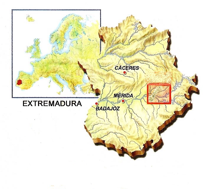
![]() The Extremadura is located in the west of Spain, in an area bordering with Portugal; it forms a vast extension of territories mainly flat or with soft mountains crossed by rivers Tajo and Guadiana, and by many tributaries. This immense territory which occupies 41,634 km2, is sparsely populated; its population density is less than that of Spain (25 inhabitants per square kilometer), which has enabled the survival of numerous natural habitats little disturbed by humans.
The Extremadura is located in the west of Spain, in an area bordering with Portugal; it forms a vast extension of territories mainly flat or with soft mountains crossed by rivers Tajo and Guadiana, and by many tributaries. This immense territory which occupies 41,634 km2, is sparsely populated; its population density is less than that of Spain (25 inhabitants per square kilometer), which has enabled the survival of numerous natural habitats little disturbed by humans.

The natural resources of the region are used by a powerful primary sector, with a great importance given to agriculture and livestock, as allows the presence of a significant extension of dehesas (pasture). These dehesas, shaped by oaks, have the characteristic formation of the thinned forest that combines traditional agriculture, livestock, forestry and hunting.
From time immemorial, the dehesa habitat was used by the cranes in their wintering grounds in the west of the Iberian Peninsula, through the fruit of oak called "acorn", which provides a rich and nutritious food for frequent travelers winged. The cranes also benefit from grain fields irrigated or not in the different phases, such as seeding or stubble, and in the latter case, particularly from rice and corn, each time with more intensity, with or without the wooded meadows and a wide variety of different crops: beans, lupins, tomatoes, sunflower, peanut, rapeseed, olive ... The mild climate during the winter and the relative tranquility of these areas offer a suitable environment for their winter stay.
The region has 30 000 hectares of rice crops, which are used by cranes as feeding grounds, as well as roosts, also using the shores of the many existing dam lakes (embalses), open fields and the banks of ponds, especially those that offer calm conditions and are close to their feeding grounds.
The crane is present in 50 areas across the region, occupying about 44% of all of its territory, mainly in the province of Badajoz and, to a lesser extent in the province of Cáceres. The wintering areas are very different in size and population of birds, they vary at each moment of the wintering period. The area called Zona Centro differs from others because it brings together between 60-70% of the total number of cranes that winter in Extremadura and almost 50% of the population of cranes of all Spain.
During the winter period of 2014-2015, censuses were conducted nearly throughout the entire region in December and January, with 121,341 and 132,903 respectively counted cranes; amounts that make up the region as the main area of wintering in Europe.
At the same time, there is in the region a team monitoring the cranes marked that does working pioneer in Spain, performing the most exhaustive control of these birds since the early 1990s, with controls of birds from all countries marked with colour combinations.
This team is covered for a few years by the group "GRUS-Extremadura", whose member are the following:
Manolo Gómez, José A. Román Fernando Yuste, Luis Salguero, JA Sánchez Martín Kelsey, Paloma Iglesias, Anabel Moreno, Borja Maldonado, Chema Traverso, Manolo Calderón, Emilio Peña, Goyo Navarro, José C. López, Alfredo Mirat, José Mr. Hernández y Ehrhardt Hohl
Information : Manuel Gómez Calzado
