The Camargue
![]()
![]()
Information : Alain Salvi / Aves 53/2 2016 49-68
A vast complex of wetlands spread over 150,000 ha, the Camargue presents itself as a mosaic of very diverse environments around the Rhône delta. Large areas are also devoted to agriculture (rice, other cereals, etc.). They are never very far from large and shallow water bodies that serve as sheds or nesting areas for many waterbirds. In this regard, the Camargue is identified as a region of major ornithological importance for many groups (Flamingos, Ardeidae, Anatidae, Laro-limicoles, paludicole passerines in particular ...) in Southern Europe and even for all the western part of the Mediterranean Basin.
Geographic location
On the other hand, its geographical location away from the main traditional European migration routes of Common Cranes makes the occurrences of this species exceptional in the 20th century despite particularly favorable Camargue environments. The first known winter records date from December 1999 (67 individuals). They were consolidated with a few hundred Cranes who stayed all winter from 2004. The workforce then continued to grow steadily to reach around 10,000 during the winter of 2015-16.

In the fall, field observations show that the migratory flows converging towards the Camargue come from two major directions, the east and the north.

Postnuptial migration of Common Cranes in the east, the south of France and neighboring regions since 2008 (blue). Ocher zones: arrival corridors for Cranes from the Central European route.
La Sotonera
![]()
Description
The large Sotonera reservoir west of Huesca was put into service in 1963. During spring migration, thanks to its strategic position, it is used as a last stop for cranes before crossing the Pyrenees mountains between mid-February and mid-March.
Numbers accumulate when bad weather with strong winds and heavy rainfall prevent birds from crossing the mountains and up to 40,000 or even 80,000 birds have been counted on those occasions.
The most spectacular moments to observe cranes are in the morning when the weather is fine and large groups soar to cross the Pyrenees, disappearing behind the sierras near Riglos.
During winter (November – February) 1,000 to 2,000 cranes, wintering in the Sotonera, feed in the surrounding area.
In Montmesa the village just North of the reservoir, a small information centre has been set up
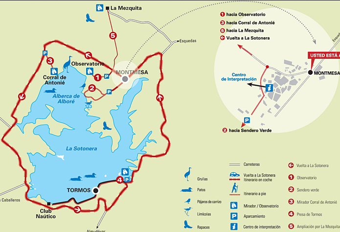
To get at the best places to watch cranes take the track that goes West from Montmesa.
After 300 m. you will cross a small bridge and the track divides into three.
On the left (item 1) you go to the Observatory (600 m, good for photographers), on the right (item 5) you go to La Mezquita where the largest numbers can be seen when they take off and straight ahead it will lead you to some old farm buildings named "Corral de Antonié". For the Corral de Antonié (item 3) turn left at the next junction and left again after 200 m. This spot gives you good views over an older reservoir called Alberca de Alboré, which is now part of the Sotonera reservoir and traditionally the most important resting place for cranes. When Alberca de Alboré is filled, groups of cranes gather on the island close to Montmesa.
Management
The site is protected as an Important Bird Area (IBA), the responsible organisation for this being the Aragón Government, but no management plan exists. Farmers are compensated with European subsidies for damage cranes may produce when feeding.
Since 1980 regular counts are carried out by the Huesca Bird Society called Grupo Ornitológico Oscense (GOO) and published on their website www.avesdehuesca.com.
Information : Grupo Ornitológico Oscence
Translation : Grupo Ornitológico Oscence & Stanislas Zaborowski
![]()
Flavignac
![]()
![]()
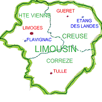
The Limousin area is made up of three departments: Haute-Vienne (area capital for fire arts and porcelain), Creuse (Gueret) and Correze (Tulle).
Some geographical contrasts:
The area is made up of a layered landscape of plains, plateaux and mountains from west to east, with a basin in the south:
- some mountains in the east with a peak at 976 m: the Mont Bessou in Correze,
- some terraced plateaux from 300 up to 700 m high around the Limousin mountains,
- the Brive basin, a rich land and a door towards the South.
The Kingdom of trees and water:
Water is omnipresent in Limousin with:
- two large hydrographical basins: the basin of the Loire in the north and the basin of the Garonne in the south,
- three large artificial lakes: the lake of Val (north-east of Correze), the lake of Vassiviere (Haute- Vienne and Creuse) and the lake of St-Pardoux (Haute-Vienne),
- numerous lakes on which cranes sometimes stop for a while in order to take rest during the
migration (some immature cranes sometimes stay a bit longer, particularly in the spring).
The forest covers a third of the territory. The broad-leaved trees (beech, oak and chestnut trees) represent two thirds of the wooded surface whereas the evergreen trees are rather located in the mountain areas.
A mainly oceanic climate:
The climate changes according to the altitudes:
- on the Limousin mountain: a more continental climate,
- on the plateaux: a transition climate with a strong oceanic predominance,
- in the Brive basin: an Aquitaine type climate.
Agriculture :
The area is famous for its livestock farming (Limousin cows, sheep, ...).
The regional nature parks and the national nature reserves:
Thanks to a territory with natural, cultural and human resources, the Limousin has two regional nature parks:
- the regional nature park of Millevaches,
- the Perigord Limousin regional nature park on which the site of Flavignac is located (Long: 01°03'18''E - Lat: 45°43'53''N),
as well as two national nature reserves:
- Tourbiere des Dauges (Long: 01°25'17''E - Lat: 46°00'42''N),
- Etang des Landes (Long: 02°19'29''E - Lat: 46°10'49''N) located at Lussat in Creuse. The largest lake of the Limousin (100 ha) has some exceptional ornithological resources. Numerous cranes take a break there before starting again their migration.
The Common Crane:
This emblematic bird arouses many passions. The Limousin is entirely swept by the west migration corridor of the Common Crane, with a higher flight frequency over Haute-Vienne and Creuse. We can estimate that the majority of the cranes wintering in Spain and in the South of France (140,000 to 200,000 cranes) flies over our area.
Flavignac:
The site of Flavignac is located at the axis of the migration corridor at 25 km north-west of Limoges.
For around twenty years, numerous ornithologists have observed there many birds. One of the first ones has been Patrick Labidoire. For around ten years, the site is lead by an ornithologist of the village: Patrick Precigout.
The site is a real lookout tower for this corridor crossed by many birds, with two main bird-watching places at around 350 m high:
- for the postnuptial migration: near the hamlet of Cessaguet which is an open space towards the north-east and from which the city of Limoges can be seen,
- for the prenuptial migration: near the hamlet of Eynanças.
A continuous presence is carried out during the migration period, particularly by Patrick Precigout and Jean-Louis Vareille who operate an accurate counting of all the birds and particularly of the Common Cranes.
The site of Flavignac has henceforth joined the Reseau Mission Migration (www.migraction.net).
Information: Alain et Sylvie GENDEAU
(Reseau Grues France)
Hortobágy National Park
![]()
![]()
![]()
The Common Crane was a breeding species in Hungary up to the end of the 19th century, the start of the water regulation programmes carried out alongside the course of the large rivers and connecting marshlands. However, Hungary is one of the most important staging-over sites for the Common Crane in Europe as outlined in the followings.
Up to the end of the 1970-ies, Lake Kardoskút in South-Hungary was the most important roost site for cranes during spring and autumn migration periods.
From the beginning of the 1980-ies, its role was more and more taken by some artificial fishponds in the Hortobágy, which can be explained by the following reasons:
- desiccation of the Lake Kardoskút because of a long droughty period
- intensive hunting in the same spot
- reduced hunting activities in the Hortobágy
- fortunate, but unvoluntary synchronization of draining large fishponds (normal way of fishing) and peak time of migration.
Consequently, the peak number of staging cranes in the Hortobágy increased from 3,000 in 1983 to 65,000 to 1993 and then to 120,000 in 2015, which still continues to increase . Cranes roost in 3-15 roost sites annually depending on the amount of precipitation filling up marshes. Roost sites are occupied by 2,000-70,000 cranes from mid-September to late November with peak numbers in late October.
However, it is important to note the increase of the number of non-breeding, oversummering cranes: this number has increased from 200 in the early 80-ies to 600 to the present time. In mild winters occasional overwintering also occurs.
Recognizing the importance of the Hortobágy in the survival of the Common Crane, the Hortobágy National Park Directorate started a programme aiding this process:
- all sort of hunting is banned in and near roost sites
- even public access is limited in such areas
- it became an important consideration in marshland reconstruction programmes to provide suitable roost sites for cranes
- maize is sown in arable lands inside the NP to attract cranes to less disturbed areas
- showing the way of life of the Common Crane is an important feature in the study paths of the NP raising public awareness.
Informations : Zsolt Végvári (Hortobágy National Park)
Hesse
![]()
![]()
In the Hesse region, the migration of Common Cranes has been followed since 1987.
In Autumn and spring, 20 to 25 people count the migrating cranes every day. Martin Kraft sends the results of the counts to the migration specialists every evening through the list « grus-grus ».
These counts are very important for the survey of cranes in Europe and particularly in autumn for France as the birds which are seen in the Hesse region will normally then head towards the north-east of France (Lorraine and Champagne-Ardenne).
To get an optimal visibility, the counts are made from several places situated on higher elevations, between 300 and 400 metres above see level around Marbourg, on a 70- kilometre long line roughly centred on Marbourg, between Alsfeld (40 km east of Marbourg) and Herborn (30 km south-west of Marbourg).
The most important of these places are the roof of the Department of biology in the Marburg Lahn mountain (some 400 metres above see level), the Marburger Hasenkopf, west of Marbourg (340 metres) and the Altenberg in Odenhausen in the Lahn valley, about 17 km south of Marbourg (300 metres).
Informations : Martin Kraft.
Le lac du Der-Chantecoq
![]()
Der Chantecoq Lake : a regulator
Covering 4,800-hectares, lake Der-Chantecoq is the second largest artificial lake in western Europe. This reservoir was created to regulate the river Seine to avoid its devastating floodings in Paris and to support its flow in summer. The lake is fed by a canal that branches off the river Marne in Saint-Dizier and the outflow is a canal that joins the Marne in Arrigny.
Interest of the lake for birds
Situated on a major migration route between the northern breeding grounds and the wintering areas of France, Spain and Africa, it started attracting numerous species of birds as soon as it was created in 1974.
The filling up of the lake between December and June followed by its drain between July and November make the landscapes change drastically. When the water recedes, mudflats appear, attracting waders, ducks and geese, gulls but also the emblematic Common Crane thanks to which this site has acquired its international reputation.
The lake and the cranes
Lake Der-Chantecoq is very attractive for the Common Crane. It provides this bird :
- a vast open space which is ideal for this wary bird
- predator free islands where thousands of cranes can gather every evening and spend the night from October to March
- pastures, meadows, oaks providing acorns, and fields (corn fields in particular) all around the lake
- a vast undisturbed space, as the access to most of the lake is forbidden at this time of the year.
This lake is the main stopover and wintering site in Europe for this species. Every year, between 200,000 and 350,000 cranes stop there, either for a few hours or to overwinter. The last record dates back to 11th November 2014 when 206,000 Common Cranes where counted as they were leaving the lake early in the morning ! Some 20,000 to 30,000 cranes now regurlarly overwinter there.
This lake is a wintering site of major importance in Europe for many species of birds, therefore its preservation is essential.
History of the counts
A particular attention is paid to this species and numerous data have been collected :
- Synthesis of the survey work carried out (maximum number of birds per period of ten days)
- Historic of all crane counts on the main European sites (the page opens on the counts at Lac du Der. Use the tabs at the bottom of the page to display another site)
Translation : Gérard Rolin
Rhin-Havelluch
![]()
![]()
The Rhin- und Havelluch (with biggest concentrations near Linum and Nauen) is the most important staging site for cranes in Germany. The region is mainly used by cranes of east European origin (Poland, Baltic States, and Finland). Numbers until 2007 are only covering the Rhinluch with the roost site Linum. Informationen: Heidrun Beckmann, Landesamt für Umwelt - Naturschutzstation Rhinluch
Diepholz Moorniederung
![]()
![]()
The Diepholz Moorniederung
![]() The Diepholz Moorniederung is situated in the south-west of the state of Lower Saxony, between the towns of Bremen, Hanover and Osnabrück. The natural area covers some 1,180 square kilometres, including 240 sq kms of marshland and peat bogs
The Diepholz Moorniederung is situated in the south-west of the state of Lower Saxony, between the towns of Bremen, Hanover and Osnabrück. The natural area covers some 1,180 square kilometres, including 240 sq kms of marshland and peat bogs
Vaasa : Söderfjärden
![]()
Söderfjärden is located about 10km south of Vaasa/Vasa, a small Finnish coastal town. It is a round farmland area about 2300ha in size, formed by a meteorite impact which happened more than 500 million years ago.
It is one of the most important resting areas for cranes and geese during autumn in Finland. The number of cranes, which cannot be compared to those present in renown areas of Germany, France or Spain, is nevertheless significant for the country.
Cranes fly back every evening to their sleeping areas in the archipelago close to Söderfjärden and they set off at sunrise. They feed on barley in postharvest stubble as many geese and ducks also do.
An annoying issue is that Söderfjärden is not a nature reserve and cranes are often disturbed by geese hunters
In the spring, first cranes come after mid-March but they stay only for some hour or a day before they continue their migration continues to their nesting sites in the north. Most of the cranes follow up to the NW, over the Gulf of Bothnia towards Sweden, the other cranes go north following the Finnish coast and some of them stay there ( representing the local population) and spread out in all directions.
There are now many parking lots along small roads in the western parts of the area. You will use them if you come by car. Previously this was a real problem because the roads were for farmers and their agricultural machinery.
Observations and counting cranes are made by members of a local bird club MLY http://www.merenkurkunlty.net/ (only in Finnish)
Most regular watchers are Aarne Lahti, Matti Maskulin and Harry Seppälä.
In the centre of the area there is a Visitor Centre supported by a local village association, Sundom Community Association. Web pages http://www.meteoria.fi/ made by Association contains more information of the area and are worth of visit, too.
In the Visitor Centre there is a bird-watching tower and a car park.
Information : Harry Seppälä
Warta Mouth National Park
![]()
![]()
 Warta Mouth National Park Warta Mouth National Park is situated in the west of Poland, near the German border.
The Warta river which flows in the middle of the park is a natural separation between the north polder and floodplains to the south.